
A Hucknall History
Huthwaite Introduction
Huthwaite addresses a large village, rapidly populated through 19th century expansion. Gradual growth over two millennium barely attracted attention, so unfortunately left few clues of earliest occupation between randomly periodic archaeological discoveries. The reason it was long better known as Hucknall was never fully resolved. A comprehensive history can finally conclude that mystery.
Spelling and name variations ultimately recognised a formerly called Hucknall Huthwaite eventually establishing a past coal mining community. Grounds covering around two square miles finally gained use centrally supporting easterly residential growth branching off a single highway connection. Hopes of asserting town status never materialised, but the prospering village township managed to achieve individual parish rights before Hucknall Huthwaite Urban District Council officially reclaimed Huthwaite name in 1907.

Huthwaite proudly claimed the highest point in Nottinghamshire. Measuring a modest 668.8ft can only be compared to this county having few places rising much above 600ft. Strawberry Bank offered closest reference for the exact spot, when those steep slopes identified all undeveloped grounds above. 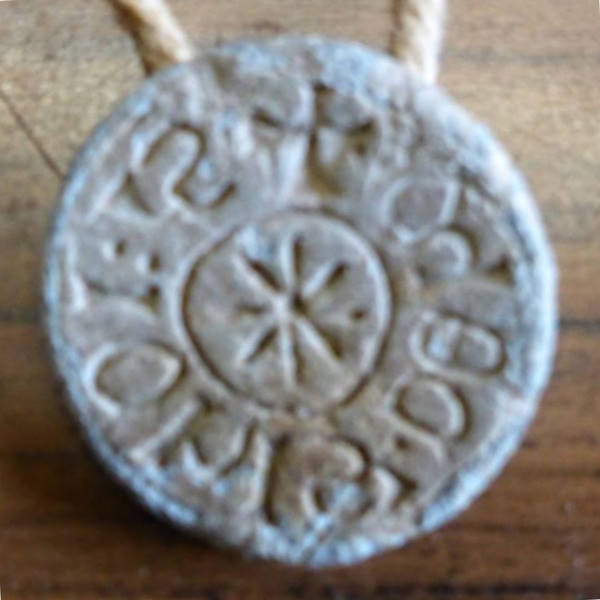 This prominent ridge had strongly suggested earliest defensive siting of an Iron Age fortification. An enthusiastic search claimed discovery of a periodic brooch. Although a personal seal is still a remarkable find, everything points towards a 9th century Huthwaite Viking settlement.
Height giving distant views over adjacent Derbyshire meadows in UK, East Midlands region of England, closely oversees a westerly boundary further defining Sutton town, Ashfield district, plus Nottinghamshire borders. These poor farmlands had been historically enclosed inside greater ancient expanse of Sherwood Forest, before that crown interest reclassified worthless waste commons beneath Huthwaite farms. Their reference to a far earlier district authoritatively once known as Hucknall asserted alternative name.
Documenting anciently influential parish church and Mansfield Manor court affairs provided enlightening evidence, noting they also adopted local Hucknall addressing following higher influential use by county administrators. And under protective sheriff custody asserting this part of the 16th century royal forest boundary, they next introduced another name identifying Dirty Hucknall.
Privileged access to some of those rare archives eventually permitted esteemed town historians to present their irrefutable and well referenced understandings. Being the larger village primarily based around its ancient church, Sutton parish boundaries contained this secondary settlement sharing tied historic interests. Developing Sutton into an industrialised commercial town centre ought further recognise broadening effects from Britain registering a population explosion. That was generally a good indication of overall prosperity leading into an industrial revolution, although many areas struggled affording keep for any more agricultural labourers.
Hucknall-under-Huthwaite
Wealthier land owners had only managed to farm a small concentrated percentage of this 800 acre coverage. The enclosure of all Sutton forest waste lands finally opened grounds for potential expansion, although allocation of sloping clay fields would come to realise more profitable use constructing cottages suitably housing ever more families seeking employment among nearby mines.
Transformation from an 18th century rural Hucknall Huthwaite hamlet slowly gained momentum powering the steam age. Several coal pits had been exploited along these Derbyshire borders long before reaching deeper Nottinghamshire seams. Like every other surrounding locality, one of those larger mines had been sited below Blackwell Road, housing their Pit Row workforce on Pit Lane.
The historical and probably most descriptively titled Hucknall-under-Huthwaite, became a villa introducing quite cramped residential expansion forming Yards along full west side the primary and future named Main Street. Besides farming and mining, the necessity of supporting poorest parishioners with suitable types of work is when Frame Working Knitting machines were introduced to those dwellings. Mass employment of most family members will therefore commonly find FWK occupation among census listings.

Detailing further historic developments is greatly assisted by gaining access to many other records like maps, local press archives and county trade directories. Modern industrial progression might best be marked beginning from 1876. Year was when a larger company began sinking their replacement New Hucknall Colliery. They foresaw employment for upward 1,500. Considering that number actually represented the entire existing population can simply indicate its future influential significance in Huthwaite.
Huthwaite
Supplying piped water mains finally enabled broadest expansion. Housing streets for mass arrival of a workforce soon established a mining community. Urban councillors were further responsible supplying mains gas for lighting streets and homes, plus amenities improving health and sanitation, educational and leisure facilities. Encouraging beneficial corporate enterprise introduced railed trams for affordable commuting. That safe use of electricity came long before wiring streets then homes with magical light switches.
Huthwaite should also share historic pride being individually recognised among the Ashfield district, which all won far wider repute manufacturing hosiery. Distinction was founded from consistent quality produced by the earlier FWK cottage industry. Powered factories maintained related clothing production. It had been regarded as a secondary supportive industry when Huthwaite sited a vast CWS factory complex, although total combined trade seems to equal if not surpass far prouder number of colliery employees
Witnessing recent dramatic changes follows highly significant loss of the National Coal Board industry. Subsequent closure of the entire hosiery manufacturing trade soon after devastated any remaining community spirit. Lower meadows had begun establishing an industrialised area advantaged by nearby motorway road networks. Manufacturers established various alternative skilled trades, widely ranging from coffins to internationally marketed luxury boat building before favouring huge national distribution centres.

Some sense of pride was restored. A widely popular scenic golf course lies adjacent plantation of now very beautifully matured Brierley Forest heritage parkland. Huthwaite still attracts 21st century residential expansion. New housing estates additionally cover past industrial sites. Newest residents might therefore hear similar taunts faced by earliest migrant miners. They were offered a proudly accepted answer, but updated research can fully clarify past confusions why this was once known as Dirty Hucknall.
07 May 03 by Gary Elliott Updated 12 Sep 20